Google Maps for Dhaka city buses and Bangladesh Railway

Google Maps has introduced its impressive new feature Google Transit, which allows the commuters in Bangladesh to access public transport information.
Starting today, Google Maps will show routes, stops, and estimated travel times to assist commuters in planning their journeys using public transportation. This feature is primarily made available for public buses inside Dhaka and Bangladesh Railway operated trains.
With Google Transit, commuters who are new to the locations or unfamiliar with routes can have a more accurate estimation of their journeys. The app UI and functionality also remain simplistic. For example, if one had to travel from the National Parliament House to the Lalbagh Fort, you would just have to type in the two locations. Google Transit will then instantly provide walking directions to the nearest bus stop, details of which bus to take, stops along the route, estimated journey duration, and fares.
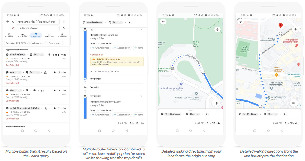
Users can access public transport directions using the simple steps:
- Open Google Maps app on Android or iOS device
- Enter destination and tap the ‘Directions’ icon or tap the ‘Go’ icon and enter the ‘Source’ and ‘Destination’ locations
- Tap the ‘transit’ icon (if it’s not already selected) to view route and stop information
- Tap a recommended route to view more information on the route’s stoppages; and
- Tap any bus-stop to see a list of scheduled buses and their destinations
“Following previous Google Maps launches for Bangladesh, such as two-wheeler navigation mode, and turn-by-turn voice navigation in Bangla, we are glad to see Google’s continued investment in providing a better transportation experience for our citizens. As the Bangladesh government’s flagship digital transformation program, a2i is excited about Google Maps is now launching public transportation information which will include bus and train schedules to facilitate more informed trip planning. It’s a remarkable example of citizen-centric innovation that is commonplace in more developed countries. We are confident that this will result in greater convenience and predictability, and reduced cost and time to travellers.” Anir Chowdhury; Policy Advisor, a2i (Aspire to Innovate) Programme, ICT Ministry & Cabinet Office, Government of Bangladesh and UNDP Bangladesh.
Google Maps globally provides over 1 billion km worth of transit results every day, and has schedules for more than 3 million public transit stops worldwide. Google Transit is now available for hundreds of cities across dozen of countries, with new partners joining all the time.

Recent Posts
Grameenphone’s ‘alo’ Launches Eid Campaign with Smart Solutions for Loved Ones
Grameenphone has launched its Eid campaign for alo, an innovative IoT ecosystem, unveiling its first-ever…
Walton launches 13 new models of Hybrid Solar Solutions for green and sustainable energy
The country's leading technology product brand Walton has released 13 new models of Hybrid Solar…
Eid Travel Made Easy: Thousands Choose Pathao Rentals
This Eid, Pathao Rentals proved once again why it’s the go-to travel solution for thousands…
Infinix to Introduce Next-Gen AI and Premium Metal Design Smartphone
The global innovative tech brand Infinix has made waves at MWC 2025, showcasing a stellar…
Xiaomi Launches Redmi Note 14 Pro & Redmi A5 in this Eid
Xiaomi, Bangladesh’s number one smartphone brand and global tech giant, hosted a grand launch event,…
Walton launches 3 new models of Online UPS under arc brand
Walton has launched 3 new models of Online UPS in the market to provide uninterrupted…